- Témaindító
- #1
- Csatlakozás
- 2022.11.12.
- Üzenetek
- 16,909
- Reakció pontszám
- 431
- Díjak
- 6
- Kor
- 26
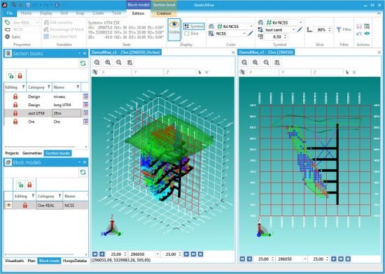
GeoticMine 1.4.9
File size: 567.8 MB
GeoticMine is the ideal tool for complex 3D geological modelling directly from Geotic databases. Our latest addition supports all the features and objects in our three other software application. It is currently the only modelling software that connects a specific point on drill hole trace in a 3D environment with a linearized and geo-referenced photograph in real time. The effect is striking.
Models can be made using sets of polylines and tie lines or automated procedures based on 3D Delaunay-Voronoi triangulation, or a combination of both. GeoticMine also include all the features needed for the volumetric integration and interrogation of block models created by geostatic software such as Isatis, Vulcan, Gemcom or Datamine.
In addition to its advanced modelling capabilities, GeoticMine enables you to create vertical, inclined or horizontal sections and projections with the simplicity and ease-of-use that Geotic products are known far. Drill hole planning in a 3D graphics environment that takes historic deviations into account is a practical tool that our clients will certainly appreciate.
Features
User-friendly and intuitive environment under Windows 10 or more, 64 bits version
Multilingual (English, French and Spanish)
Import and export of block model
Ellipsoidal search
Import formats VDCL, VDML, DWG, DXF, OFF, ASC.
Export formats VDCL, VDML, DWG, DXF, ASC.
Optimized for SQL databases.
Multi-user environment.
Image georeferencing.
HOMEPAGE
Code:
                   ⚠
                    A kód megtekintéséhez jelentkezz be.
					Please log in to view the code.
DOWNLOAD
Code:
                   ⚠
                    A kód megtekintéséhez jelentkezz be.
					Please log in to view the code.