- Díjak
- 6
Free Download Aquaveo Groundwater Modeling System (GMS) 10.8.6 | 945.2 mb
Aquaveo, a water resources consulting company, is pleased to announce availabilityGroundwater Modeling System (GMS) 10.8.6is the most advanced software system available for performing groundwater simulations in a three-dimensional environment.
What's New in GMS 10.8.6 - Date: July 10, 2024
MODFLOW
15088 Using "3D Dataset > Array" for Specified Vertical Cells in RCH Crashes GMS
15195 HK Arrays Aren't Importing to GMS
15220 Horizons to HUF Tool Crashes GMS
Borehole
15170 Horizons to Ugrid Tool Results in Identical Grids Whether or Not the Horizons Coverages are Used
UGrid
15213 Mapping to Quadtree/Octree doesn't update canvas correctly
Display
15223 Error: Invalid breaklines detected (cross empty space) with no breaklines
Export
15230 Unexpected Error Occurs When Exporting the HGS Simulation
MODFLOW6
15199 MF6 array not showing
15200 MF6 CHD Package Time-series files add row generates unexpected error
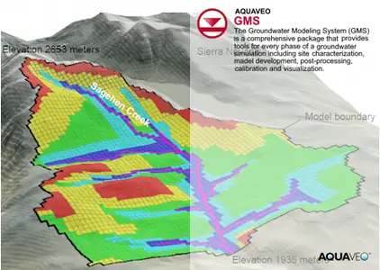
TheGroundwater Modeling System (GMS)is a comprehensive graphical user environment for performing groundwater simulations. The entire GMS system consists of a graphical user interface (the GMS program) and a number of analysis codes (MODFLOW, MT3DMS, etc.). GMS was designed as a comprehensive modeling environment. Several types of models are supported and facilities are provided to share information between different models and data types. Tools are provided for site characterization, model conceptualization, mesh and grid generation, geostatistics, and post-processing.
GMS
Instructional videos for the Groundwater Modeling System (GMS) program developed by Aquaveo.
Aquaveois a pioneer of GIS-based software solutions for hydraulic, hydrologic and groundwater modeling. Our products have been refined over two decades to create the most advanced environmental modeling and visualization software available. In addition to interfacing with industry standard numerical models, we develop custom desktop and cloud-based applications tailored to specific needs. Aquaveo began as a part of the Engineering Computer Graphics Laboratory at Brigham Young University in 1985. The lab was reorganized and the name was changed in September, 1998 to the Environmental Modeling Research Laboratory (EMRL). In April, 2007, the main software development team at EMRL entered private enterprise as Aquaveo, LLC.
Owner:Aquaveo
Product Name:Groundwater Modeling System (GMS)
Version:10.8.6 Premium
Supported Architectures:x64
Website Home Page :www.aquaveo.com
Languages Supported:english
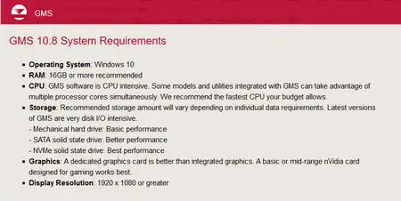
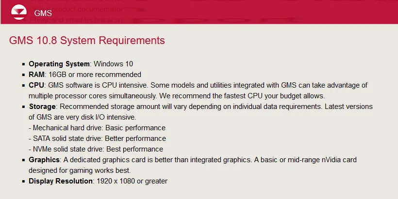
System Requirements:Windows *
Size:945.2 mb
xAquaveo Groundwater Modeling System (GMS) 10.8.6
Close
Added by 3% of the overall size of the archive of information for the restoration

xAquaveo Groundwater Modeling System (GMS) 10.8.6

Close
Recommend Download Link Hight Speed | Please Say Thanks Keep Topic Live
Code:
A tartalom megtekintéséhez szükséges:
Bejelentkezés
vagy
Regisztráció